


का विवरण Locus Map Free - Outdoor GPS navigation and maps
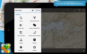
Navigation with offline maps for fully enjoyable outdoor experience. Create, plan, edit, record, save or share your trips, keep the memories, track your performance and much more. Locus Map is designed for hiking, mountain biking, cycling, running, geocaching, cross-country skiing and other outdoor activities. Find a range of cool functions running above variety of maps of the whole World:
Hiking, cycling and other sports:
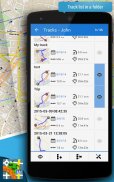
Routes and interesting places:
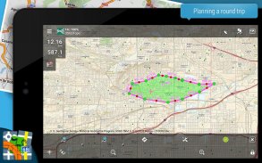
• plan your routes along hiking trails, bike trails or in open field
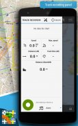
• record your tracks with all useful statistics – distance, speed, tempo, altitude, calorie burn and more
• import and export the routes in different formats (KMZ, GPX, TCX...)
• share your tracks on Strava, Runkeeper, GPSies or Google Earth
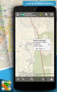
• create own database of interesting or favorite places
• display photos on the map
• import and export POIs (points of interest) in various formats
• find detail information about track points or important places
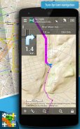
Offline navigation and guidance:
• sound and voice navigation working offline adjustable for hiking, cycling or a car
• sound alert when missing the route
• navigation along routes imported from elsewhere
• on point guidance in open field
• sound notification of an upcoming point of interest
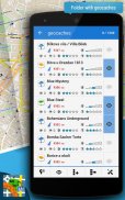
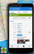
Geocaching:
• geocaches download for offline geocaching
• on-cache navigation above the map or using the compass
• online and offline logging, graphical and calculation tools
• field notes management
• sound alert of an upcoming geocache
Other handy functions:
• audio coach – sports tracker with voice information about your performance
• live tracking – share your location in real time
• smart GPS – saving the battery of your mobile device
• parking assistant – finds your car in the crowded parking lot
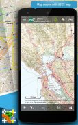
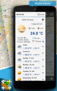
Select from a wide portfolio of maps:
• LoMaps - offline maps of all the World - switch them to hiking/biking map, winter or city map. FREE DOWNLOAD of the first 3 LoMaps.
Detailed hiking maps and cycling maps of the best world map publishers:
• Great Britain by Ordnance Survey (Explorer, Landranger),
• USA by USGS classic/satellite, NeoTreks (AccuTerra),
• Canada by BackRoad Map Books,
• maps of Switzerland by SwissTopo, Belgium by IGN Belgium, France by IGN France, Denmark by Kortforsyningen, Iceland by LMI Atlas Map, Netherlands by Map5.nl, Slovenia by PZS Maps, Spain by CNIG maps, Sweden by Lantmäteriet, Poland by Compass, Germany, Austria and North Italy by Kompass, Outdooractive – Summer and Winter maps, Basemap.at and Freytag-Berndt, Czechia and Slovakia by SHOCart and Geodézie Online
and many others...
• support of external maps in SQLite, TAR, MBT, GEMF, Orux or RMA formats, and of own OpenStreetMap or map themes
App uses the Device Administrator permission.
Locus Map Free is highly customizable. You can set everything according to your needs!
Do you want Locus Map to handle even more functions with no limits? For example bike computer with full support of external bluetooth and ANT+ sensors? Then download Locus Map Pro!
Homepage:
https://www.locusmap.eu
Help desk:
http://help.locusmap.eu
Manual:
http://docs.locusmap.eu
पूरी तरह से सुखद आउटडोर अनुभव के लिए ऑफ़लाइन मानचित्रों के साथ नेविगेशन। अपनी यात्राएं बनाएं, योजना बनाएं, संपादित करें, रिकॉर्ड करें, सहेजें या साझा करें, यादें रखें, अपना प्रदर्शन ट्रैक करें और बहुत कुछ। लोकस मानचित्र हाइकिंग, माउंटेन बाइकिंग, साइकल चलाना, दौड़ना, जियोकैचिंग, क्रॉस-कंट्री स्कीइंग और अन्य बाहरी गतिविधियों के लिए डिज़ाइन किया गया है। पूरी दुनिया के विभिन्न प्रकार के नक्शे पर चलने वाले शांत कार्यों की एक श्रृंखला खोजें:
लंबी पैदल यात्रा, साइकिल चलाना और अन्य खेल:
मार्ग और दिलचस्प जगहें:
• योजना हाइकिंग ट्रेल्स, बाइक ट्रेल्स या खुले मैदान में अपने मार्गों के साथ
• सभी उपयोगी आंकड़ों के साथ अपने ट्रैक रिकॉर्ड करें - दूरी, गति, गति, ऊंचाई, कैलोरी जला और अधिक
• विभिन्न प्रारूपों में मार्ग आयात और निर्यात करें (केएमजेड, जीपीएक्स, टीसीएक्स ...)
• स्ट्रैवा, रंकीपर, जीपीएस या Google धरती पर अपने ट्रैक साझा करें
• दिलचस्प या पसंदीदा स्थानों का अपना डेटाबेस बनाएं
• मानचित्र पर फ़ोटो प्रदर्शित करें
• विभिन्न प्रारूपों में आयात और निर्यात पीओआई (ब्याज के अंक)
• ट्रैक पॉइंट या महत्वपूर्ण स्थानों के बारे में विस्तृत जानकारी प्राप्त करें
ऑफलाइन नेविगेशन और मार्गदर्शन:
• ध्वनि और आवाज नेविगेशन हाइकिंग, साइकल चलाना या कार के लिए ऑफ़लाइन समायोज्य काम करना
• मार्ग खोने पर ध्वनि चेतावनी
• नेविगेशन आयातित मार्गों के साथ कहीं और से
• बिंदु खुले मैदान में मार्गदर्शन
• ब्याज के आने वाले बिंदु के ध्वनि अधिसूचना
Geocaching:
• geocaches ऑफ़लाइन जियोकैचिंग के लिए डाउनलोड करें
• मानचित्र के ऊपर या कंपास का उपयोग करके ऑन-कैश नेविगेशन
• ऑनलाइन और ऑफलाइन लॉगिंग , ग्राफिकल और गणना उपकरण
• फ़ील्ड नोट्स प्रबंधन
• आने वाले भूगर्भ के ध्वनि चेतावनी
अन्य आसान कार्य:
• ऑडियो कोच - आपके प्रदर्शन के बारे में ध्वनि जानकारी वाले स्पोर्ट्स ट्रैकर
• लाइव ट्रैकिंग - वास्तविक समय में अपना स्थान साझा करें
• स्मार्ट जीपीएस - अपने मोबाइल डिवाइस की बैटरी को सहेजना
• पार्किंग सहायक - भीड़ वाली पार्किंग स्थल में आपकी कार पाती है
नक्शे के विस्तृत पोर्टफोलियो से चुनें:
• LoMaps - सभी दुनिया के ऑफ़लाइन मानचित्र - उन्हें हाइकिंग / बाइकिंग मानचित्र, सर्दियों या शहर के मानचित्र पर स्विच करें। पहले 3 लोमैप्स की मुफ्त डाउनलोड।
सर्वोत्तम विश्व मानचित्र प्रकाशकों के विस्तृत लंबी पैदल यात्रा मानचित्र और साइकिल चलाना मानचित्र
• ऑर्डनेंस सर्वे (एक्सप्लोरर, लैंडरेंजर) द्वारा ग्रेट ब्रिटेन
• यूएसए यूएसजीएस क्लासिक / उपग्रह, नियोटेक्स (AccuTerra) द्वारा,
• बैक रोड मानचित्र पुस्तकें द्वारा कनाडा
• आईजीएन बेल्जियम द्वारा स्विट्ज़रलैंड के मानचित्र, बेल्जियम आईजीएन बेल्जियम द्वारा फ्रांस , डेनमार्क Kortforsyningen द्वारा << बी> आइसलैंड एलएमआई एटलस मानचित्र द्वारा, नीदरलैंड Map5.nl द्वारा, स्लोवेनिया पीजेड मैप्स द्वारा, स्पेन सीएनआईजी मानचित्रों द्वारा << बी> स्वीडन लैंटमाएरिएट द्वारा, पोलैंड कम्पास द्वारा, जर्मनी, ऑस्ट्रिया और उत्तरी इटली कॉम्पास द्वारा, आउटडोर - ग्रीष्मकालीन और शीतकालीन मानचित्र, Basemap.at और Freytag- बर्न्द, चेकिया और स्लोवाकिया SHOCART और Geodézie ऑनलाइन द्वारा
और बहुत सारे...
• बाहरी मानचित्रों का समर्थन SQLite, TAR, MBT, GEMF, Orux या RMA प्रारूपों में, और अपने स्वयं के OpenStreetMap या मानचित्र विषयों में
ऐप डिवाइस प्रशासक अनुमति का उपयोग करता है।
लोकस मैप फ्री अत्यधिक अनुकूलन योग्य है। आप सब कुछ अपनी आवश्यकताओं के अनुसार सेट कर सकते हैं!
क्या आप लोकस मानचित्र को किसी भी सीमा के साथ और भी फ़ंक्शंस को संभालने के लिए चाहते हैं? उदाहरण के लिए बाहरी ब्लूटूथ और एएनटी + सेंसर के पूर्ण समर्थन के साथ बाइक कंप्यूटर? फिर लोकस मैप प्रो! डाउनलोड करें
होमपेज:
https://www.locusmap.eu
सहायता केंद्र:
http://help.locusmap.eu
मैनुअल:
http://docs.locusmap.eu
Locus Map Free - Outdoor GPS navigation and maps - Version 4.21.1
(25-01-2024)

Locus Map Free - Outdoor GPS navigation and maps - एपीके जानकारी
एपीके संस्करण: 4.21.1पैकेज: menion.android.locusLatest Version of Locus Map Free - Outdoor GPS navigation and maps
Apps in the same category
You may also like...


